Thursday, January 28, 2016

Free Frank McWorter and New Philadelphia

Free Frank era buildings moved to townsite
Traveling along US-36/I-72 in Pike County, Illinois (about 20 miles east of Hannibal, Missouri) you encounter highway signs that proclaim that this is "Free Frank McWorter Historic Memorial Highway" and there are signs to "Free Frank McWorter Gravesite".  Being the smart-aleck that I am, I have often wondered why?  Who or what is free?  Is it the highway?  Is it Frank?  Or is the attraction free?  Through time, other signs were added for "Free Frank McWorter gravesite New Philadelphia" and "New Philadelphia founder Free Frank McWorter gravesite, National Register of Historic Places".  If it's good enough for the National Register of Historic Places, it should prove to be somewhat interesting.  Nadienne and I were looking for something to eat, so it was a good place to get off the road.

Town plat in incorporation documents
At first glance, old New Philadelphia is nothing to look at; just an open field.  There are some old buildings on the site.  They are not original to New Philadelphia, but were built in the same era.  A recent owner of the land moved them here for preservation.  If you look hard, you can make out the town plan - looks like a bunch of squares.  The two buildings above sit on lots 7 and 8 of block 3, just about the corner of King and Ann Streets.  It was founded, it grew as the US population migrated north and west, then shrank as the US population moved into bigger cities.  The town was not impressive in just about any way, except in who founded the town, to what purpose the town was founded and the groups of people that lived here.  All of the stuff that you can't read in the land.

New Philadelphia


Town plan in 1872
The townsite itself was plotted as 144 lots, each measuring 60 ft x 120 feet.  Each block contained 8 lots.  The gravels streets were planned so that the major streets (Broad and Main) were 80 ft wide, the secondary streets were 60 ft wide and alleys were 15 ft wide.  The town occupied a total of 42 acres.

New Philadelphia was founded in 1836 by a former slave, Free Frank McWorter.  Although colonies of freed blacks had been established before, this town was different.  It is the first town platted and legally registered by an African-American prior to the Civil War.  Free Frank used the proceeds from sales of lots to buy the freedom of his children and grandchildren who were still enslaved at that time.  New Philadelphia is also one of the first wholly integrated towns in the United States, where whites, blacks, and biracial people lived willingly side by side on equal footing.  The only facilities that appear to be segregated are the cemeteries, as even school facilities were integrated (although some accounts maintain that there was a school for whites and a school for blacks until 1874).  There is no clear picture as to why that might be, but I think that the cemetery for blacks started as the McWorter family cemetery and expanded to include extended family and friends.

New Philadelphia population trends 1850-1880
Each lot in town for sale to individuals was sold, and many sold multiple times.  It was an attractive investment at the time, with land speculators first betting on the Illinois-Michigan canal passing the town site and later, that railroads would build stations there.  A store was established in New Philadelphia in 1839 and a post office existed by 1850, along with a blacksmith shop, wheelwright, two shoemakers and two cabinet makers.  Total population climbed steadily from 58 residents in 1850 to a peak census population of 171 in 1865.  It is interesting that this town founded by a black man always had a majority white population.  The black population held steady until a postwar influx of freed southern slaves in 1865, but the population across all categories declined from that point forwards.

Racial balance in New Philadelphia 1850-1880
The decline of New Philadelphia was brought about by a complex variety of factors.  One of the largest may be the routing of the Hannibal and Naples to the north of New Philadelphia.  During this time frame, rural areas were depopulating because of movement of people to larger cities and to the newly opened western states.  In 1885, the eastern blocks (1, 10,  11, 20) and the eastern half of the adjoining blocks (2, 9, 12, 19) were declared vacant and returned to agricultural use. This eradicated Maiden Lane and Canton Street.  Queen Street was renamed Stone Street.  These changes shrank New Philadelphia down to 27.5 acres.  By the early 20th century, about 6 households were left in town, mostly involved in farming.  By the 1940s the townsite was almost totally abandoned.

Modern aerial map with town grid overlay

Free Frank McWorter


Bust of Free Frank McWorter based on descriptions
and pictures of descendants.
Outside of being a fully integrated antebellum town founded by a former slave, the story of New Philadelphia itself is as unremarkable as the story of its founder is amazing.  Free Frank McWorter was born a slave in 1777 South Carolina's Piedmont region (Union County) near the Pacolet River.  His mother was an African woman named Juda and his father was most likely her owner, George McWhorter.  He was of mixed race and is described in various documents of the time as "yellow" or "mulatto".  Being a slave, he was known at this time simply as Frank.  

He was moved to Pulaski County, Kentucky in 1795.  It is quite possible that my 6x great-grandfather Nicholas Jasper knew McWhorter and Frank, since the Jaspers lived in Union County, South Carolina in the 1770's before moving to (and naming) Pulaski County, Kentucky.  In 1820 and 1830, several Jaspers are found on Census pages adjoining Free Frank, so they lived nearby.  Free Frank married a slave woman named Lucy from the neighboring farm of a distant McWhorter family connection, William Denham.  At this time, marriages between slaves carried no legal standing, since a slave was the property of their owner.  Frank fathered four children while enslaved: Judy, Sally, Frank and Solomon.  By 1810, Frank was allowed to hire himself out for work, and was allowed to keep any monetary amount beyond that charged by McWhorter for his slave's work.  Frank also set up a saltpeter mining operation, providing a key ingredient for gunpowder manufacture.

Lucy McWorter c. 1870 painting by George Neal
from family daguerreotype 
When George McWhorter died in 1815, he made no provision for the manumission (freeing from slavery) of Frank, so Frank was transferred with the rest of the estate property to McWhorter's heirs.  By 1817, Frank had saved enough money to purchase the freedom of his wife from her owner at the price of $800 (about $14,500 in 2016 money).  Already recognized as a sharp businessman, Frank demonstrates his shrewdness here, since Lucy was pregnant.  Their son,Squire, was born a free person, and that is one less purchase Frank would have to make.  Frank paid for his own freedom for the same amount from the McWhorter's.  His manumission papers were signed on 13 September 1819.  Two more children were born in freedom: Commodore and Lucy Ann.

Frank continued to live in Pulaski County, Kentucky mining saltpeter, speculating on land and farming.  By the time of the 1820 Census, Frank had adopted the name Free Frank, announcing his status as a free man.  In 1829, Free Frank traded his saltpeter operation for Frank Jr.'s freedom.  By this time, Frank Jr. had escaped to Canada, and this business deal allowed him to return to the United States a free person.  In 1830, Free Frank is listed as Free Frank Denham in Pulaski County, Kentucky with two sons, two daughters, Lucy and himself listed as free colored persons.

Interpretive sign in information kiosk at roughly the corner of Broad
and North Streets
Remaining free could be a tricky proposition for a black person in antebellum USA.  Kidnappers could seize a free person, burn their papers and sell them back into slavery.  Free Frank wished to gain some breathing room by moving to a free state.  He was able to buy a quarter section of land (160 acres) on the Military Tract of Illinois from Dr. Galen Elliott.  In 1830, Free Frank and his free family moved north, wintering in Greene County, Illinois.  During the trip, Frank Jr. lagged behind his parents, decreasing the chance that kidnappers could capture all of them.  All told, the family would fetch about $4000 on the slave market (about $105,250 in 2016 money).  They arrived on their land in Hadley Township, Pike County, Illinois in spring of 1831.  An early history of the county noted that "the first white man to settle Hadley Township was a black man".

This was a turbulent time in Illinois politics.  Bordering slaveholding states on the south and west, political maneuvering was taking place to variously make Illinois a slave state, a free state, a slave state that barred free blacks and finally an all-white state barring all blacks.  Free Frank's land ownership circumvented a requirement by Illinois at the time for free blacks to post a $1000 ($26,000 2016 dollars) bond before emigrating to Illinois.

Free Frank set to rapidly improving his land, and had 80 acres in production within two years, using tools that he brought with him from Kentucky.  He farmed oats, barley, flax, potatoes, cattle, hogs and horses.  Lucy helped in the operation by raising poultry, making butter, cheese, and collecting honey.  The farm was successful enough that Free Frank could buy another 80 acres directly south of his farm and buy his son Solomon from slavery by 1835.  This additional 80 acres was used to lay out the town of New Philadelphia in 1836.  In all, Free Frank owned 600 acres of Illinois land.  When Free Frank incorporated the town, it was noted that he intended to used the profits from the sales of town lots to purchase the freedom of his family that remained enslaved.  

1872 property map of Hadley Township around New Philadelphia
Illinois law did not very clearly spell out the rights of freed blacks to own land.  In addressing this, 14 white citizens of Pike County vouched for Free Frank's character.  He then petitioned the Illinois legislature for a legal last name (McWorter), allowing his children to take his name, and spelled out his rights as a citizen, having "the right to sue and be sued, plead and be impleaded, purchase and convey both real and personal property in said last mentioned name".  This created precedent for all free blacks to own property.  By the time that Free Frank McWorter died in 1854, he had purchased the freedom of his children remaining in slavery, as well as his daughter-in-law Louisa and two grandchildren.  His will directed his heirs to purchase the freedom of the rest of the family, which occurred prior to the start of the Civil War.  In all, he purchased the freedom of 16 individuals at a cost of about $14000 (2016 equivalent, about $370,000).

It is an amazing story.  A man born a slave, establishing a business, buying freedom for his family and himself.  The arc of success continued throughout Free Frank's life, he started a town, that fostered a tolerant society, secured property rights for blacks in Illinois and left his family in position to carry on his legacy.  Many of the McWorter's remained as farmers after the demise of New Philadelphia in 1885, but most have scattered across the country, still building up a stronger, better nation.  Their story can be seen in part on an episode of Time Team America (Season 1, Episode 3).

Getting There


Much work is still being done in terms of archaeological study of the site.  When we visited, there was a covered kiosk for the interpretive signs.  It appears from pictures that individual house sites are being marked as they are uncovered.

From US-36/I-72, exit at Barry, Illinois (exit 20).  Take County Highway 4 south to Illinois Highway 106.  Turn east on IL-106.  Turn northeast onto County Highway 2 east to New Philadelphia townsite at 360th Ln.

Waypoint:  Latitude 39.698023 N; Longitude 90.961322 W

Monday, January 25, 2016

Rock Creek Station XP: Where "Bill" Hickok Became "Wild"


McCanles fight according to legend
James Butler "Wild Bill" Hickok is another of the Western men whose legend eclipsed the man.  Dime novel hero, crack pistol shot, cold eyed killer, a fine specimen of rugged Western manhood, protector of feminine virtue, gambler, lawman.  Finding the event that gave birth to the legend is not difficult, but wrestling away fiction from fact is another story, altogether.  The birthplace of the "Wild Bill" legend is Rock Creek Station, near Fairbury, Nebraska and his fight with the "notorious McCanles Gang".

Much of Wild Bill's legend stemmed from his physical presence.  A large muscular man with steel gray eyes, flowing auburn locks and mustache, he was attractive to the ladies and intimidating to other men.  From a young age, he trained himself to be a crack shot, and loved to have an audience at target practice.  The more people that knew he could shoot well, the fewer he would likely have to fight.  By all accounts, he was calm under fire, and once he decided to shoot, he would shoot to kill.

One of the players in the Rock Creek incident, Sarah Shull remembered Hickok:  "Hickok has steel-blue eyes that were beautiful and gentle but could change in a second and look dangerous.  You had better watch his eyes; he wasn't one to run from a fight."

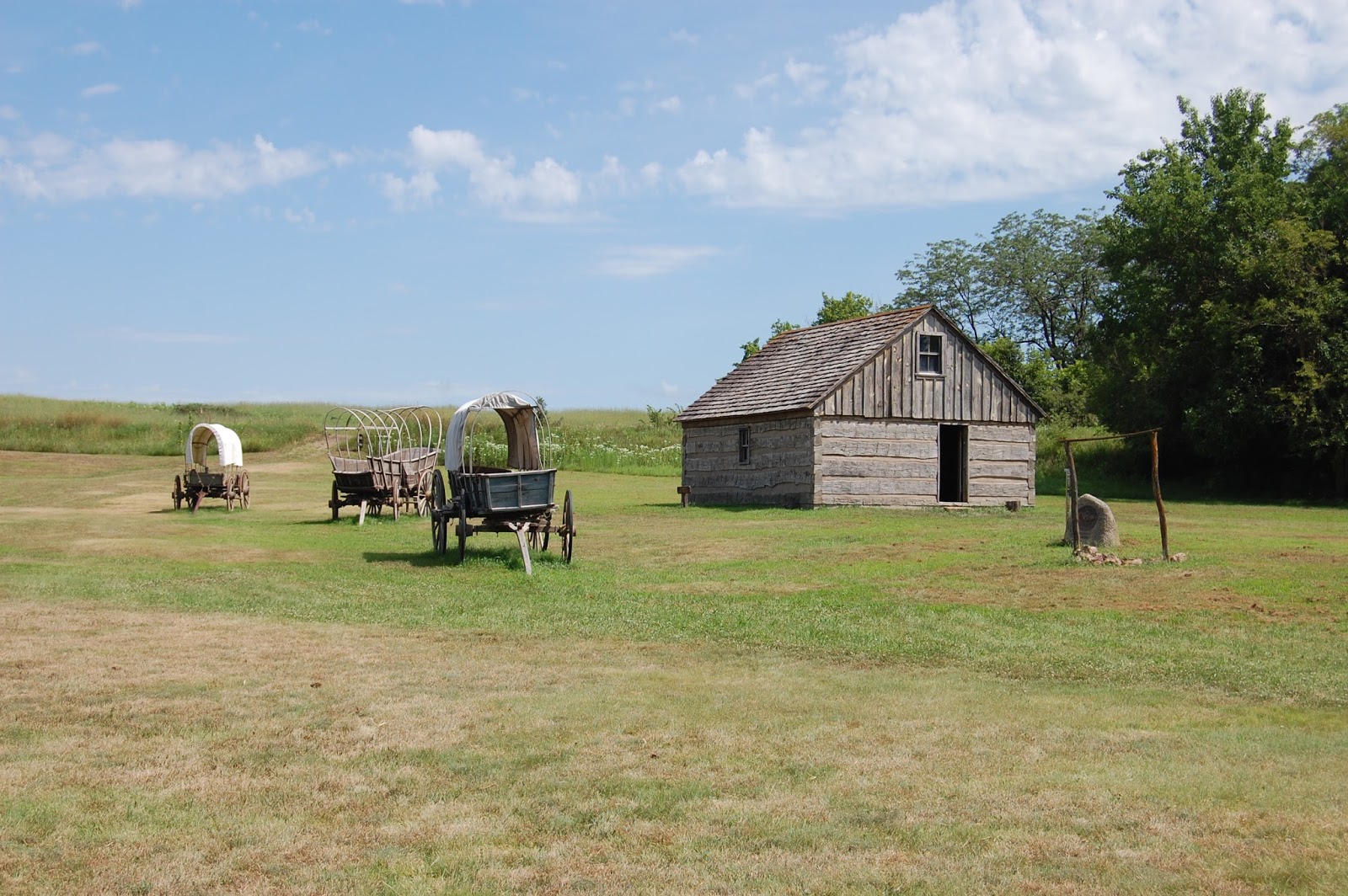
Wild Bill and the McCanles Gang - According to Hickok (Abridged)


Reconstructed Rock Creek Station Cabin
When recounting the story of shooting at Rock Creek Station, Bill paints Dave McCanles as the bully leader of a gang of murdering desparadoes, horse-thieving cutthroats who terrorized settlers on the Nebraska-Kansas border.  Hickok states that he was a scout for the US cavalry bringing through soldiers from Camp Floyd when he rode up to the station on 12 July 1861.  He says he found the station superintendent's wife in hysterics, her husband shot dead.  Hickok was in the house when the Gang rode up dragging a minister to the station by the neck with a rope.

Dave McCanles c. 1859
Recognizing Hickok's horse, McCanles comes into the front door of the station cabin with a gun drawn.  Hickock shoots Dave McCanles through the heart, which only enrages the nine men with him.  As the men poured into the cabin, Hickok opens up with his pistol, killing four more men.  The fight becomes a desperate hand to hand struggle during which Hickok shoots one man, knocks another one out before he is shot with shotgun pellets and struck with a rifle butt.  In the confused fight he gains a knife and starts slashing at the rest of the men, eventually subduing them all before walking a way, falling into a faint.  He claims to be shot with 11 buck shot and cut in 13 places, all of the knife wounds being life-threatening.

It is a great story and really entertained Colonel George Ward Nichols, who wrote it up for Harper's Weekly in 1867.  Problem is, it is a story and a greatly inflated one at that.  When Hickok was put on trial for McCanles' murder, there was not a scratch on him.  Furthermore, the dead superintendent, felled by a shot in the head, was present at the trial as a co-defendant.  There were not 11 dead men at the station, rather there were only three; McCanles; his cousin and a hired-hand of McCanles'.  There is also no pay record that would substantiate Hickok's claim that he was serving as a scout for the cavalry.


Getting to Rock Creek - Wild Bill


James Butler "Wild Bill" Hickok
Like many other colorful figures of the American West, James Butler Hickok was born in what seems to be a much tamer environment, Homer (now Troy Grove) Illinois on 27 May 1837.  Raised by devout Baptist parents, William and Polly (Butler) Hickok, young James yearned for fame and honed his shooting skills as soon as he could.  His parents became caught up in the abolitionist movement, and the family home reportedly served as a station on the "Underground Railroad".  Once his father died, James provided game for the family to eat, relying on those sharpshooting skills.

In June 1856, James headed out west for the newly opened Kansas Territory.  At this time, settlers were strongly polarized into pro-slavery (Missourians/Border Ruffians) and anti-slavery (Free State/Free Soil/Jayhawkers) factions.  James Butler Hickok joined with James Lane's Free State "army" and became Lane's personal bodyguard.  Hickok was also looking for land to farm and staked a 160 acre claim in modern-day Lenexa, Kansas.  He was elected a constable in Monticello Township, Johnson County, Kansas in 1858.

Setup of the inside of the cabin
It was during this time that James Hickok started using the aliases William Hickok and William Haycock.  He would also be nicknamed Shanghai Bill and Dutch Bill, although it is difficult to see the reasons.  Finding out that his claim had been preempted, Bill struck out to see more of the West.  He was employed first as a teamster for the freighting company of Jones and Cartwright from 1858 - April 1861.  He arrived at Rock Creek Station shortly after Horace Wellman took over as station superintendent for Russell, Majors and Waddell's Pony Express.  Exactly what Bill's role was at the station is unknown, since there is no evidence that he was actually an employee of Russell, Majors and Waddell.  It is possible that Wellman personally hired him as a stockhandler or even as an enforcer.

Getting to Rock Creek - Dave McCanles


Reconstruction of West Ranch building
Not nearly as much is known about the other man that figures in this fight, David Colbert McCanles.  We know he was born in Iredell County, North Carolina on 20 November 1828 and moved with his family to Watauga County, NC.  Records show that he served as deputy sheriff of Watauga County from 1852-1856 and sheriff from 1856-1859.  Descriptions picture him as a large, powerful man.  He married young, listed as a farmer in Watauga County in 1850 with wife Mary (18 years) and son William M. (Monroe), age 1.

Reconstructed toll bridge between West and East Ranches
David later took a mistress, Sarah Shull, abandoning his family by 1859 and heading west with Sarah.  Originally headed to the Colorado gold fields, he was dissuaded from traveling all of the way by returning and disappointed gold-seekers.  He bought the Rock Creek Station property from Newton and S.C. Glenn.  The property was crossed by the Oregon-California Trail and did a business in supplying emigrants and serving as a campground.  He soon built a toll bridge over the creek there, charging 10-50 cents per wagon to cross.  The original ranch was on the west side of the creek, but he was soon able to set up a ranch on the east side, as well.  Apparently having a change of heart about his family, he sent east for his wife and children, but Sarah remained as a "domestic".  What Mary thought of this arrangement I do not know, but it was likely not comfortable.

Census entry for McCanles family in Jones County, Nebraska Territory, 1860

Reconstructed bunkhouse of East Ranch
It is agreed that Dave McCanles was a man who liked to have his way, and he would push other people around to further his desires.  It is thought that the appearance of Hickok in the community upset the balance of power in the neighborhood,  Many historians suggest that Sarah Shull was taken with Hickock and welcomed his advances, inciting McCanles' jealousy, although Sarah later stated that this was not so.  Even if this is true, it was only a contributing factor to the fight.  The most immediate cause was McCanles' impatience with collecting a debt from Russell, Majors and Waddell, whose company was bankrupt following the loss of mail contracts.

Stable and corral


Russell, Majors and Waddell's Central Overland California and Pike's Peak Express Company had leased the east ranch from McCanles in 1861, then arranged to buy it in April 1861 for 1/3 down, with the rest of the payment due in three monthly installments.  At that time the company was not making payroll on time and was behind on the payments.  Having been left holding the bag by a freight company one other time, McCanles was determined to either get his money or get his property back.  He just wasn't entirely sure whether the company was not going to pay up, or if Wellman had already received the money, but was keeping it for himself.

Rock Creek Station Accomodations - Sir Richard Burton


Sir Richard Burton c. 1875 painting by Frederic Leighton
Noted explorer Sir Richard Burton (not the actor, rather the translator of The Arabian Nights), stayed here on 08 August 1860 and wrote in his book City of the Saints, and Across the Rocky Mountains to California:

"A weary drive over a rough and dusty road, through chill night air and clouds of musquetoes, which we were warned would accompany us to the Pacific slope of the Rocky Mountains, placed us about 10 P.M. at Rock, also called Turkey Creek surely a misnomer ; no turkey ever haunted so villainous a spot! Several passengers began to suffer from fever and nausea ; in such travel the second night is usually the crisis, after which a man can endure for an indefinite time. The 'ranch' was a nice place for invalids, especially for those of the softer sex. Upon the bedded floor of the foul "doggery" lay, in a seemingly promiscuous heap, men, women, children, lambs, and puppies, all fast in the arms of Morpheus, and many under the influence of a much jollier god. The employes, when aroused pretty roughly, blinked their eyes in the atmosphere of smoke and musquetoes, and declared that it had been 'merry in hall' that night the effects of which merriment had not passed off. After half an hour's dispute about who should do the work, they produced cold scraps of mutton and a kind of bread which deserves a totally distinct generic name. The strongest stomachs of ,the party made tea, and found some milk which was not more than' one quarter flies. This succulent meal was followed by the usual douceur. On this road, however mean or wretched the fare, the station- keeper, who is established by the proprietor of the line, never derogates by lowering his price." Burton would declare Rock Creek Station "the ne plus ultra of Western discomfort".

The McCanles Murder According to Monroe McCanles (Abridged)


Front door of cabin, Oregon Trail coming from left
Monroe would say that Dave McCanles, James Woods, James Gordon and himself arrived unarmed at the East Ranch.  His father directed him to stay outside and entered the cabin.  A shot rang out and Dave stumbled out, collapsed and died trying to say something to his son, but was unable.  Woods and Gordon had been looking for McCanles stock and harness, but hearing the shot, ran up to the house.  Woods approached from the rear and Gordon approached from the front.  Both were apparently shot by Hickok.  Grabbing a hoe, Mrs. Wellman chased off Monroe, started yelling "Kill them all" and hacked Woods to death with the hoe.  Gordon made a break for the timber, but was followed by his dog, which gave his whereabouts away.  It was unclear who fired the shot that killed Gordon, and he was buried on the spot.  Monroe was able to follow a dry creek bed to safety, and alert his mother to what had happened.  The mother then sent for Dave McCanles' brother James, who alerted authorities in Beatrice, Nebraska.

Rock Creek property after the McCanles affair

What really happened?


Hickok at about the time of the Rock Creek Station incident
Nobody can really know for sure, but by cutting the stories from the two camps down the middle, we can probably come pretty close.  This is likely a fight that is more about McCanles and Wellman than Hickok.  David McCanles had accused Jane Wellman's father of stealing, and had allegedly beaten the older man earlier.  Earlier in the month, McCanles had sent his son Monroe with Wellman to try to collect payment from the section head of the Central Overland Company in Brownville, Nebraska.  While they were away, McCanles tried to push Mrs. Wellman into turning over the ranch property to him.  She had no use for McCanles and let him have an earful.

David McCanles usually carried a shotgun on his saddle and two pistols on his person, which was not unusual in this place at that time.  It is reasonable to assume that he was armed on 12 July 1861.  He likely brought Monroe with him to convince the Wellmans that he did not expect violence.  Both versions of the story say that David approached the ranch house and asked to see Wellman.  He was probably not expecting to see Hickok in the house.  McCanles made it clear that he wanted to see Wellman and expected him to come out or be dragged out.  Seeing some movement in the back of the house (which would have been dark) he asked for a drink of water, which Hickok got him, before Hickok stepped back into the house.  A gunshot rang out, striking McCanles in the chest.  Who fired it is unknown, but it was likely a nervous Wellman.

Subpoena for Monroe McCanles
If Wellman fired the shot, Hickok may not have immediately known which man shot, but he was now committed to the fight. Seeing Woods and Gordon rushing to the house, and having to assume that they were armed, it is likely that Hickok shot both of them with his pistol. Jane Wellman wanted blood and called for all of them to be killed, taking a swipe at Monroe McCanles with the grubbing hoe, before turning it on the badly wounded Woods and hacking him to death. Monroe and Gordon both ran for cover, but Gordon's dog followed him into the brush, and the station hands followed the dog to Gordon. It is not clear who fired the final shotgun blast, although it may have been J.W. "Doc" Brink.

Criminal complaint against Dutch Bill,
Wellman and Brink
Monroe ran home to tell his mother what happened. The following day, James (LeRoy) McCanles swore out a criminal complaint of murder in Beatrice, Gage County, Nebraska against "Dutch Bill, Dock and Wellman (thier other names not known) committed the same". It has been alleged that McCanles made fun of Hickok by calling him "Duck Bill" because his upper lip protruded over his lower lip, but a misspelling in other court documents referring to "Duch Bill" probably gave rise to the notion. Another good story bites the dust.


When the arresting party arrived at Rock Creek Station on 15 July, the station men went along peacefully. The trial was speedy, occurring 15, 16 and 18 July 1861. Although Monroe was subpoenaed, the judge in the case refused to let him testify (perhaps because of his age) and had him removed from the courtroom during testimony. With only the stationmen's testimony to go by, and given the threats apparently issued by McCanles to Wellman, the judge ruled that the men had acted in self-defense.


Bunkhouse with stable and corral behind
Was this a proud moment in the Hickok legend? Certainly not, but as the legend grew in popularity, he was likely caught up in the story as much as he had been in the original events. Some McCanles relatives and allies would like you to believe that Hickok was a complete fraud, a coward and a murderer of a quiet family man. Some Hickok allies would like you to believe that he was a superhero who rid the neighborhood of a wicked bully. Hickok's reputation would not have risen to the level it did if he was without bravery or virtue, and there would be no sympathy for McCanles had he been completely evil. They were humans, and in this case caught up in events that took on a life of their own. Stories without heroes and villains are not comfortable, and this is a very uncomfortable story. You can find reason to sympathize with and also dislike each of the major characters in this story. Nope, not real satisfying, but interesting all the same.

The Dime Novel


Most of the dime novels were complete fabrications or there was nugget of truth in the premise of the story that was greatly exaggerated.  The problem with these stories when they make characters out of live people, is that you lose the boundaries of what is real and what is fantasy.  When you tell tall tales often enough, the story becomes the fact.  My favorite illustration of this process is from the miniseries Wild Times, starring Sam Elliot as Hugh Cardiff, a Buffalo Bill-like character.  The following is a scene in which three shootists including Cardiff are telling tall tales to a dime novel author:

[Hugh, Doc and Caleb are spinning yarns for Bob Halburton, a writer of western dime novels]
Hugh Cardiff: Bob, I recall the time that me and Caleb here was carryin' dispatches for an...
Doc Bogardus: That was, ah, Phil Sheridan, I recall.
Hugh Cardiff: Yeah, General Phil Sheridan. We was crossin' through some hostile Indian country and we got jumped by a band of forty Cheyenne.
Caleb Rice: And thirty Arapaho and two Ute.
Hugh Cardiff: And old Caleb here, he took care of thirteen of them Cheyenne with those two pistols you see hanging right there in that belt. And understand, Bob, he only fired twelve shots - now one of 'em went through two of those Indians and killed 'em both.
Caleb Rice: It had probably gone on and killed another one, except there weren't any more left. We had killed them all by that time.

It is easy enough for me to see Buffalo Bill and Wild Bill Hickok sitting around telling such stories to eastern greenhorns like George Nichols.

Last Laugh?


Rear Admirals Byron (left) and Bruce McCandless with USS McCandless
It is difficult to measure the value of one man in life against another.  Wild Bill Hickok served the US Army as a teamster, scout, and perhaps spy during the Civil War.  He was a lawman in Hays, Kansas and Abilene, Kansas and celebrity figure before he was killed in Deadwood, South Dakota by Jack McCall on 02 August 1876.  He died without children, so the Hickok contribution to American history stops there.  

Dave McCanles' son Julius, changed the name to McCandless, perhaps to escape notoriety, or just to match the actual spelling to the phonetic.  Julius' son Byron became a commodore in the US Navy (later updated to rear admiral), earning the Navy Cross as commander of the destroyer USS Caldwell during WWI.  During WWII, Byron was in charge of the San Diego Repair Base, earning the Legion of Merit for his performance and the ability of his command to return battle-damaged ships to service.  Commodore McCandless also designed the Flag of the President of the United States, as well as the Presidential Seal in 1945.  Byron's son Bruce McCandless attained the rank of rear admiral, earning the Congressional Medal of Honor for his performance on the cruiser USS San Francisco during the Battle of Savo Island (Guadalcanal) during WWII.  Bruce's son, Bruce II, became a naval aviator and an astronaut.  He served as CAPCOM during the Apollo 11 mission.  Bruce McCandless II flew on the Space Shuttle as a mission specialist twice, making the first untethered spacewalk in the history of human spaceflight.  The frigate USS McCandless (FF-1084) was named for Byron and Bruce McCandless.   Regardless of Dave McCanles' history, his family accounts for some of the most storied achievements of the 20th Century, and that legacy continues today.  Certainly any perceived debt owed society by David McCanles has been more than repaid by his offspring.

USS San Francisco Memorial at Land's End.  Note the battle damage on the salvaged section of the ship

Navy Cross Citation for Byron McCandless:

"For distinguished service in the line of his profession as commanding officer of the USS Caldwell, engaged in the important, exacting and hazardous duty of patrolling the waters infested with enemy submarines and mines, in escorting and protecting vitally important convoys of troops and supplies through these waters, and in offensive and defensive action, vigorously and unremittingly prosecuted against all forms of enemy naval activity."

Medal of Honor Citation for Bruce McCandless:

Lt. Commander Bruce McCandless
"For conspicuous gallantry and exceptionally distinguished service above and beyond the call of duty as communication officer of the U.S.S. San Francisco in combat with enemy Japanese forces in the battle off Savo Island, 12–13 November 1942. In the midst of a violent night engagement, the fire of a determined and desperate enemy seriously wounded Lt. Comdr. McCandless and rendered him unconscious, killed or wounded the admiral in command, his staff, the captain of the ship, the navigator, and all other personnel on the navigating and signal bridges. Faced with the lack of superior command upon his recovery, and displaying superb initiative, he promptly assumed command of the ship and ordered her course and gunfire against an overwhelmingly powerful force. With his superiors in other vessels unaware of the loss of their admiral, and challenged by his great responsibility, Lt. Comdr. McCandless boldly continued to engage the enemy and to lead our column of following vessels to a great victory. Largely through his brilliant seamanship and great courage, the San Francisco was brought back to port, saved to fight again in the service of her country."

Bruce McCandless II during first untethered spacewalk

Getting There


From US-77, turn west onto NE-8. From NE-8, turn north onto 573rd Ave, then east onto 710th Rd, then follow the signs to Rock Creek Station State Historical Park. There is an entry fee ($5 daily entry or $25 yearly sticker for all Nebraska State Parks) for the park and admission to the museum on grounds.

Waypoint: Latitude: 40.113760 N; Longitude: 97.060900 W
Street Address: 57426 710th Road, Fairbury, NE 68352


Further Reading


Thursday, January 21, 2016

Home: William Frederick Cody

Buffalo Bill's Wild West Show Ticket Wagon
Some names are very memorable because of associations with things or events.  Yell "Marco!" in a crowd, and someone will probably holler back "Polo!".  If you use names in association games, "Jesse" will likely prompt "James", "Wyatt" will get you "Earp", and "Buffalo" will get you "Bill".  Buffalo Bill of the Wild West: Buffalo hunter, Pony Express Rider, Indian fighter, Army scout, Congressional Medal of Honor awardee, Wild West Show promoter.  Intrepid hero?  Consummate showman?  Ultimate fraud?  Who knows for sure, probably all of the above, just like most people.

Cody Homestead House - limestone portion is original
William Frederick Cody was born in a log cabin near LeClaire, Iowa Territory, just north of the modern-day Quad Cities on 26 February 1846.  His father Isaac Cody built a handsome house of limestone on a hill in the Wipsinicon River valley of Scott County, Iowa with walnut floors and trim.  The house stands today with some additions and serves as a museum to the Cody family and pioneer families of Iowa.  Although a celebrated native, William F. "Buffalo Bill" Cody did not spend much time at all here.  The family inhabited this particular house for scarcely a year.

Wooden frame additions to Cody Homestead
Isaac Cody, Bill's father, was a wandering sort.  From 1846-1853, the Cody's lived in four residences in and around LeClaire.  In 1850, Isaac set out for the California gold fields, but came home before he got very far, the reason for which was unknown to William Cody.  Kansas Territory was slated to open for settlement in 1854 and the family sold all of their Iowa properties in 1853 for $2000 (about $60,000 in 2016 dollars).  This may have been precipitated by the death of Samuel Cody, Bill's older brother, in a horse-riding accident.   In 1854, they left for Weston, Missouri, where Isaac's brother Elijah lived.

Bison kept on grounds of the Cody Homestead
Historic homes are interesting for several reasons, including: architectural style; sense of family style; sense of family status; and sense of family priorities.  A home can fill in some of the blank spaces in our picture of an individual.  Only two houses from Cody's boyhood are still in existence: this one and one that was moved from LeClaire to Cody, Wyoming.  Looking at this house, you can see the skill and care used by Isaac Cody to build the house, as it is still standing (with additions and renovations) after almost 170 years.  You also get the feeling that Isaac Cody liked the finer things in life, but was never quite satisfied with what he had, always chasing after the next better thing just beyond his reach.

The Codys in Kansas


Buffalo Bill's Wild West Show covered wagon
The move West was a fateful one for the Cody family.  Isaac's brother Elijah was a dry goods merchant and sold goods to emigrants on the Oregon-California Trail and settlers in Kansas at Weston, Missouri and Fort Leavenworth, Kansas Territory.  Elijah was also a slave-owner and supported the Border Ruffian cause to bring Kansas into the Union as a slave state.  Isaac originally expressed no strong political convictions, he was in Kansas for material gain.  The family settled in the Salt Creek Valley just north of Ft. Leavenworth (near present-day Kickapoo, KS), an area that was settled primarily by pro-slavery families.  Most people just assumed that Isaac was pro-slavery because they knew of his brother's stance.  When pushed to make a speech about his position at Rively's Store in Salt Creek Valley on 18 September 1854, Isaac tried to walk a fine line:  he was no abolitionist; where slavery was legal it should be left in place; he did not want to see slavery extended to new territories; in fact, he envisioned a white state in which no blacks, slave or free would be welcome.  The speech did nothing to help Isaac's position with either camp, and Charles Dunn, an employee of Elijah Cody's, stabbed Isaac twice in the chest with a Bowie knife, damaging a lung.

Wild West Show Poster
The attack was noted in the 28 September 1854 edition of the Democratic Platform (Liberty, Missouri):  "A Mr. Cody, a noisy abolitionist, living near Salt Creek, in Kansas Territory, was severely stabbed while in a dispute about a claim with a Mr. Dunn, on Monday week last. Cody is severely hurt, but not enough it is feared to cause his death. The settlers on Salt Creek regret that his wound is not more dangerous, and all sustain Mr. Dunn in the course he took. Abolitionists will yet find 'Jordan a hard road to travel!'”  You see that the notion of objective journalism is a fairly recent idea, and already out of style.

Although not active in Kansas politics up to that point, Isaac Cody became more outspoken as a Free Soil supporter and helped establish the Free State colony of Grasshopper Falls (now Valley Falls) on the Delaware River.  The Codys became marked, with pro-slavery men stealing their livestock and property, and threatening to kill Isaac should they find him.  Isaac began splitting time between Grasshopper Falls and the Salt Creek Valley, as the violence in "Bleeding Kansas" increased.  Despite the animosity between settlers in Kansas, the venom did not seem to spread in the Cody family, as Elijah continued to aid his brother and his family through the years.   In 1857, Isaac traveled to Ohio to recruit anti-slavery settlers to Grasshopper Falls.  Epidemics of scarlet fever and mumps broke out among the emigrants and Isaac Cody took ill.  He died of pneumonia at his home on 10 March 1857, his stab wounds listed as a contributing cause of death.  Isaac Cody was buried on Pilot Knob in Leavenworth, Kansas. This event pushed young William to look for work to support the family.  He found gainful employment with Russell, Majors and Waddell driving wagons at age 11.  William Cody was off on his life of adventure, becoming a personage as big as the American West itself.

Getting There


William F. Cody c. 1860
Exit I-80 at Exit 306 (LeClaire/Bettendorf) to US-67 north through LeClaire and Princeton, Iowa.  Turn west onto Bluff Road (CR-F33) just north of Princeton (you cannot miss the signs).  Take Bluff Road to 230th Ave.  Directly in front of you and just to the north will be the entrance to the Buffalo Bill Cody Homestead.  A small log schoolhouse is near the entrance, the house is further up the driveway.

Street Address: 28050 230th Avenue, Princeton, Iowa 52768

Waypoint: Latitude 41.713671 N; Longitude 90.4536868 W

Open every day April-October 9 AM - 5 PM
Admission $2

Just north on US-67 is a nice campground, Rock Creek Marina and Campground.  Turn east onto 291st Street to enter the campground.

The wagons pictured are actually in the Circus World Collection in Baraboo, Wisconsin on the grounds of what was the headquarters and winter quarters of the Ringling Brothers Circus.


Further Reading


An Autobiography of Buffalo Bill Cody

Buffalo Bill Cody Homestead

The Cody Graves in Leavenworth, KS

Monday, January 18, 2016

Pensacola Lighthouse

Pensacola Lighthouse from the beach
My Dad was in the Navy when I was growing up, and we moved all over the country in those first years, literally from sea to shining sea.  Some of my first memories are of the sounds of Newport, Rhode Island:  The sirens that sounded nothing like those on Dragnet (but sound like those in England); and the foghorn:  BAAAHHHHHHH-rummmmmmmm; silence;  BAAAHHHHHHH-rummmmmmmm.....  The foghorn works with a lighthouse to mark rocks/reefs/shoals and safe entrance to the harbor.

Lighthouses have always proved interesting to me.  At once utilitarian in function and aesthetic in design.  The sweeping beam that shows this navigational point to mariners for miles out to sea.  The earliest lighthouses were platforms upon which fires were built and lit at night.  The Argand lamp brought a smokeless light that could be placed in an enclosed tower, powered by whale oil.  Thorium lantern mantles provided a much brighter source of light.  Steam driven magnetos allowed electricity to be used to power carbon arc lamps.  The sun valve (which turned off gas flow during the day) and associated technology allowed the use of gas as a light source, until electric light technology became the standard.  Lights were rotated using multiple light sources and a clockwork system.  If the clockwork system failed, the works had to be turned by hand.

The first Pensacola Lighthouses


View next to Carriage House
The current Pensacola Lighthouse is the third example of a navigational light placed near this point.  The first Pensacola Light was a lightship, the Aurora Borealis, and was placed on the harbor side of Santa Rosa Island.  Although protected from the rough sea, it was often difficult to see from outside of the bay.

The second lighthouse was a 40 foot tower built on a 40 foot bluff at the mouth of the harbor, just west of Fort Barrancas and about a half mile east of the current lighthouse.  This building was entirely white and had 10 whale oil lamps in two clusters of five rotated by a clockwork and strengthened by a 14-inch reflector. An advantage of this light was that ships could follow the beam to enter the harbor, which was not possible with the placement of the light ship.  Despite the higher position, views of the  tower could still be blocked by trees close to the tower and those on Santa Rosa Island.  This first light would appear very stocky, 30 feet wide at the base, 15 feet wide at the top and 40 feet tall.

The third and current lighthouse

Lamp and lens - see the rainbow?
The current lighthouse was built in 1858 on the north side of the harbor entrance and entered service on 01 January 1859.  This tower is 150 feet tall on the side of a 40 foot bluff currently located on Naval Air Station Pensacola.  The light is 190 feet above sea level, which provides a considerable boost in visibility distance.  The lighthouse placement allows it to serve as the rear range light for the harbor entrance.  Range lights work in pairs, front and rear.  The rear light is always placed higher than the front light.  When the two lights form a vertical pair, the observer is on the navigation line.  If the front appears to the left of the rear, then the observer is right of the range line; if the front appears to the right of the rear, then the observer is left of range line.

Lens detail
The first lens for this light was a first order Fresnel lens.  These lenses had a large aperture and short focal length, this lens allows for more light to be collected from oblique sources.  These lights project a beam over a much broader distance.  The lens is divided into concentric annular sections.  A first order lens has a focal length of 920 mm and height of 2.59 meters.

When the US Civil War broke out in 1861, the harbor and the adjoining Navy Yard became a military target.  Union forces withdrew from Fort Barrancas and Fort McRee to Fort Pickens on Santa Rosa Island, leaving most of the harbor defenses and the Navy Yard in Confederate hands.  An artillery battle between Confederates in Ft. Barrancas and Ft. McRee on Perdido Key and the Union forces in Ft. Pickens on Santa Rosa Island broke out on 22 November 1861.  Shore batteries around the lighthouse became targets for Ft. Pickens.  During this time, the tower suffered about 6 hits.  Fortunately, none of the damage threatened the structural integrity of the tower. The Confederates evacuated Pensacola in May 1862. When Union forces came back to the tower, they found that the Confederates took the Fresnel lens with them.  On 20 December 1862, Union forces placed a fourth-order Fresnel lens in the tower, putting the tower back into service.

Entrance to Pensacola Bay
At the end of the war, the original Fresnel lens was recovered and put back into place in 1869.  The lightkeeper's residence was also built in 1869.  The daymark (paint scheme) of the tower was originally completely white, making it difficult to distinguish against a cloudy sky.  During the 1869 upgrades, the daymark was changed so that the lower third of the tower was left white to contrast it with nearby trees and the upper two-thirds of the tower was painted black to stand out against the sky. Electricity was installed in the light tower in 1939, which eliminated the need to rewind the clockwork by hand every 4 1/2 hours.

Fort Pickens on Santa Rosa Island
The light signature of this lighthouse is one white flash every 20 seconds.  The beam is very strong, being visible for 27 miles out to sea.  The lens continues to rotate during the day, even though the light is not powered.  This is necessary because the lens can focus a beam of light onto the wall of the lighthouse, creating a spot hot enough to damage the metal and masonry of the light room.  If the lighthouse loses electricity, the lens has to be moved by hand every few minutes to prevent this.

Stairs going down --- gives me the willies
The first lighthouse tower was constructed under the supervision of the Department of Treasury's Lighthouse Establishment (1791-1851).  The US Lighthouse Board of the Department of Treasury (1852-1910) was in charge during the construction of the second tower.  A more civilian Lighthouse Service within the Department of Commerce.  The Lighthouse Service was merged with the US Coast Guard in 1939 and light keepers were able to choose to remain civilians or join the Coast Guard.  The last civilian lightkeeper at Pensacola retired in 1953.  The Coast Guard operated the lighthouse from that point.  Automation reduced staffing needs in 1965.

End of Santa Rosa Island
The lighthouse was placed on the National Register of Historic Places in 1974.  By the 1980s, the site was in disrepair and a push to dismantle the outbuildings and perhaps the tower was increasing. The tower was seen as a potential hazard to jets flying out of NAS Pensacola.   Push-back from a preservation movement saved the Keeper's House and outbuildings from destruction.  In 1996, Coast Guard Auxiliary 17 started conducting tours of the lighthouse.  These were discontinued in 2007 due to liability concerns, and the grounds closed to the public.  The spiral staircase can be treacherous, with a railing only on the outside edge of the staircase.  The inside edge is unlined.  During the 177 stair climb, downstairs traffic has the right of way.  It is best for upstairs traffic to move toward the inside and hold onto a step at about eye-level, unless you can step into one of the deep window wells to let traffic pass.

In 2008, the Coast Guard allowed tours to resume under the supervision of the Pensacola Lighthouse Association.  Renovations continue on site.  The guide at the top of the tower was very well informed and helpful.  A small entry fee is charged to the site: $6.00 per adult when we went there.  The site is becoming increasingly popular, and there are a variety of tours with limited openings available at night, during Blue Angels practices and for Ghost tours.  Looking for a good place to propose?  This might be it.  Check the beach to see if someone has stomped out your message already, might save you some time and effort.

Getting There


The Pensacola Lighthouse is on the grounds of Naval Air Station Pensacola.  You will be required to present a valid picture ID for every adult in the vehicle and perhaps allow a search of the vehicle.  Have the IDs ready when you pull up to the gate.  The way is well marked, just follow the signs.  It is easy to see from the Museum of Naval Aviation.

Street Address: 2081 Radford Blvd, Pensacola, FL 32508

Waypoint: Latitude 30.3461433 degrees N ; Longitude 87.3104028 degrees W

Further Reading:

Pensacola Lighthouse and Museum


More views from the top


Lens detail

Fort McRee eroding into sea at end of Perdido Key


Above the airfield water tower

Carriage House - visitors center

Tip of Perdido Key


The kids at the top