Showing posts with label Travel. Show all posts

Friday, June 16, 2017

Birds of a Feather: Double-Crested Cormorant

Great Blue Heron and Double-Crested Cormorants at NAS Pensacola
On a dreary January day strolling the waterfront at Naval Air Station Pensacola while waiting on my son to check-in for the week, I was treated to a variety of birds going about their daily business.  On one pier, a heron and a bunch of double-crested cormorants were trying to stay dry.  Cormorants have no oil glands to help waterproof their feathers, so they have to air dry their feathers after swimming and are often seen spreading their wings to do so.  The double-crested cormorant is named for the two tufts of feathers on its head during breeding season.

Double-Crested Cormorant in the Eagle Pool at Loess Bluffs NWR
Cormorants are very distinctive swimmers.  Riding very low in the water, their heads and upper backs are the only things visible in the water.  They dive quickly and can stay submerged for up to 70 seconds and reach depths of about 30 feet.  Small fish can be swallowed under water, but most are brought to the surface before they are swallowed.  In addition to fish, they may hunt frogs and salamanders, as well as crayfish and crabs.  Indigestible materials such as bone and crustacean shell are regurgitated in a pellet like those of owls.


I first remember hearing/reading about cormorants on Captain Kangaroo in "The Story About Ping" by Marjorie Flack and illustrated by Kurt Wiese.  It stars Ping the Duck, who lives on a wise-eyed boat with his family and human master on the yellow Yangtze River.  The master lets the ducks out to feed and when they come home, master swats the last duck on the backside.  Ping, being chronically late, decides to hide rather than go home and get his spanking.  The next day he sees a lot of boats, but not the wise-eyed boat.  One of these boats has black fishing birds with hooked beaks.  These are cormorants.  The bird would catch a fish, then return to the fishing boat, where the human master would give them a bit of fish for pay.  (What the book isn't telling you is that the fishermen tie snares around the necks of the cormorants or place rings around their necks to keep them from swallowing big fish - learned that in elementary school).

Ping dove for fish, but surfaced far from the cormorants, and followed a trail of crumbs to a houseboat, where Ping was promptly caught, trapped in a basket to await becoming supper.  SUPPER?!! No wonder we were so screwed up as kids.  I can understand a witch eating bad kids, but cute little ducks?  Yeah, I know.  As an adult, I found out that ducks are delicious.

Anyway, the little boy on the boat felt sorry for Ping, and let him go.  Ping found his way home, and swam towards his family, only to find he was going to be last again.  This time, however, he accepted his swat. Not real clear about the moral of the story, but it made an impression.  I remember this story from almost 50 years ago.  It has real staying power - first published in 1933 and made the National Education Associations "Teachers' Top 100 Books for Children" list in 2007.

Narrated Story of Ping

Double-crested cormorants overwinter in the United States south of Missouri, especially coastal areas.  These birds breed in the north-central United States and south-central Canada.  In the mid-central United States, these birds make stopovers at waterholes during Spring and Fall migrations. 

Range Map of Double-Crested Cormorant

Double-Crested Cormorant Sunning at Loess Bluffs NWR

Monday, June 12, 2017

Monumental Memories: Iron Mike of Parris Island


The United States entered World War I on April 6, 1917 and its involvement would last through the end of the war in 1918.  While not our longest war and certainly not the war with the greatest loss of American life, this conflict suddenly forced America to confront the realities of new scales of destruction wrought by rapidly advancing technology.  Soldiers in this conflict were on a three-dimensional battlefield, with attack coming from the air and beneath the sea surface, as well as horizontally.  Airplanes served first as reconnaissance and observation platforms, then carried machine guns and dropped bombs. The guns were bigger, more accurate, artillery more explosive, cavalry was replaced by armored vehicles with guns.  Submarines were systematically employed in naval battle and attacking commerce.  And then there was the poison gas - chlorine gas, mustard gas - death on an industrial level.

There were 15.5-18.4 million deaths due to the fighting in WWI.  Of the dead, 117,465 were Americans.  The US military suffered 204,002 wounded in battle and 53,402 killed or missing in action.  For the US Marine Corps, there were 2,457 killed or missing in action and 8,894 wounded in action.  Many of these Marines had passed through Parris Island, which began functioning as a Marine Corps Recruiting Depot on 1 November 1915.

The mass mobilization of 4.7 million troops, a war involving most of the world's major powers, fighting on foreign battlefields, the large number of Americans buried in foreign cemeteries and the sheer horror of the fighting prompted memorialization of the Great War on a scale rivaled only by the US Civil War.  These ranged from the strikingly large Liberty Memorial in Kansas City, MO, the temple like Soldiers Memorial in St. Louis, MO to more simple markers and statues.  Some of these statues were of the uniformed "doughboy" from the war and became more informally known as "Iron Mike".

Parris Island's "Iron Mike" is one of the more striking that I have encountered. A battle-ready figured with a water-cooled Maxim machine gun slung over his right shoulder and the his left hand raising aloft an M1911 .45 caliber pistol.  Measuring nearly 8-feet tall from heel to pistol tip and placed on a 5-foot 6-inch Stony Creek granite pedestal in front of the Parris Island Headquarters and Service Battalion's barracks, this Marine figure is imposing.  The base bears the inscription "In memory of the men of Parris Island that gave their lives in the World War, erected by their comrades".


Officially known as Monument to the United States Marines, the bronze statue was created by Robert Ingersoll Aitken, who also designed the pediment of the US Supreme Court Building in Washington, DC.  Not only was Aitken a well-known sculptor, he had served as a captain of a machine gun unit in the US Army's 306th Infantry Regiment. The funds for the monument were apparently being raised informally by officers and enlisted men during the war to memorialize their fallen comrades.  Brigadier General Eli Cole, who commanded Parris Island before going to France in 1918 and returned to Parris Island September 1919.  With $8000 raised, Captain Aitken was commissioned to design the monument.  By October 1922, a site had been selected in front of the Post Inn (Hostess House) with an unobstructed view of the parade deck (which lacked grandstands at the time) and Boulevard de France.

Aitken had a wax model ready for examination in February 1923, and the design had been approved in March by Major General Marine Commandant John A. Lejeune and the Commissioner of the US Commission ofFine Arts.  Aitken's plaster model was viewed by and met the approval of Generals Cole and Lejeune in April 1923.  The statue was cast in bronze by Rowan Bronze Works and was ready for dedication on 25 July 1924.  General Lejeune gave the primary speech, and Mrs. Nellie Glen (whose two sons were Parris Island men who were killed in WWI) unveiled the statue.

Dedication of the Memorial to US Marines in 1924
Many who have been to Parris Island (visitor, volunteer or draftee) will no doubt note that this is NOT where "Iron Mike" stands today.  Expansion of MCRD Parris Island in the run up to WWII necessitated the extension of Panama Street to the west during construction for the 2nd Recruit Training Battalion,   The current location is in front of Building 144 at Boulevard de France and Santo Domingo Street.


Getting There


There is only one way onto Parris Island.  From US-21 take Malecon Dr. to the Gate.  After passing through the gate, you will encounter a traffic circle.  Take the third exit (Vieques Rd. to Malecon Rd.),   Just keep going straight and Malecon will turn into Boulevard de France.  Iron Mike is past the parade deck and Iwo Jima Monument.

You will need a REAL ID compliant drivers license or passport to enter the gate (Missouri, Minnesota, Montana and Maine drivers licenses are not compliant with the REAL ID Act and may not be accepted at federal facilities).  Visiting hours are 6 AM to 6 PM.  After 6 PM, you must have a military sponsor.  If you are visiting a recruit planning to graduate, you will only be able to enter base after 6 PM if you have reservations at the base inn.

Waypoint: Latitude: 32.349221 N; Longitude: 80.675302 W
Street Address: Boulevard de France and Santo Domingo Street, MCRD Parris Island, SC 29905

Further Reading


Postscript

Nadienne and I were eating lunch at Bricks on Boundary in Beaufort, SC before the college graduation.  A newly graduated Marine in uniform and his family were leaving and the hostess said "Congratulations!  Hope we see you again soon,"  The young Marine replied 'Thank you, Ma'am, but I hope to never see this place again".  I imagine there are many young Marines that feel that way.  But he'll change his mind, some day.  Maybe.


Tuesday, June 6, 2017

It's Our Thing: The Pelicans of Pensacola

Having traveled over a million miles in this country, I have noticed that many communities have adopted some kind of theme or mascot for branding or advertisements.  A small group of these have gone all out, creating team-building experiences for businesses, community esprit de corps, art in public spaces and tourist traps (I say that affectionately).  It might be cows or bears or even big boots.  As you walk around Pensacola, Florida you notice the abundance of pelicans.  Pelicans on signs, pelicans flying overhead, and pelican statuary.

The brown pelican (Pelecanus occidentalis) is a year round visitor in Florida.  It is warm enough during the winter that they can fish and after nesting season is over, the birds may fly up to North Carolina (they fly as far north as Nova Scotia, but only rarely).  Pelicans then return with the New Yorkers for the winter.  They are at once peculiar and graceful in flight, adopting a posture of head resting on shoulders.  They stay in large groups of both sexes throughout the year and tend to fly in groups.  They may adopt a v-formation, but are usually in a line.


It is a real treat to watch brown pelicans fish.  Flying over the ocean looking for prey, these birds pull their wings back and dive headfirst into the water, knocking fish unconscious with the shock wave generated when they hit the water.  They scoop the fish up in their pouch, return to the surface, dump water out of their pouch, swallow their prey and fly off again.  They have to watch the darned kleptoparasites - gulls, skuas, and frigatebirds have been known to swipe food from pelicans.  Pelicans can become conditioned to approaching humans for a food handout at seaside restaurants and fishing piers.

The GrandPelican - "Press"ton
2 N. Palafox
One of the most successful public art project is CowParade.  A contest to place a design on a fiberglass cow (standing, reclining, or grazing) is held and the winning designs produced and displayed throughout the host cities.  The first CowParade took place in Chicago in 1999.  Over 75 cities, about 5000 cow and 250 million viewers later, CowParade is still going strong.  After the event, cows are auctioned off as fundraisers.  The 2002 Portland event was seen by Pensacola News Journal president and publisher Denise Ivey, who thought that something similar would go over well in Pensacola.  Since Florida is not really associated tightly with cows, they came up with something unique - Pelicans in Paradise.  A Pelican Parade.

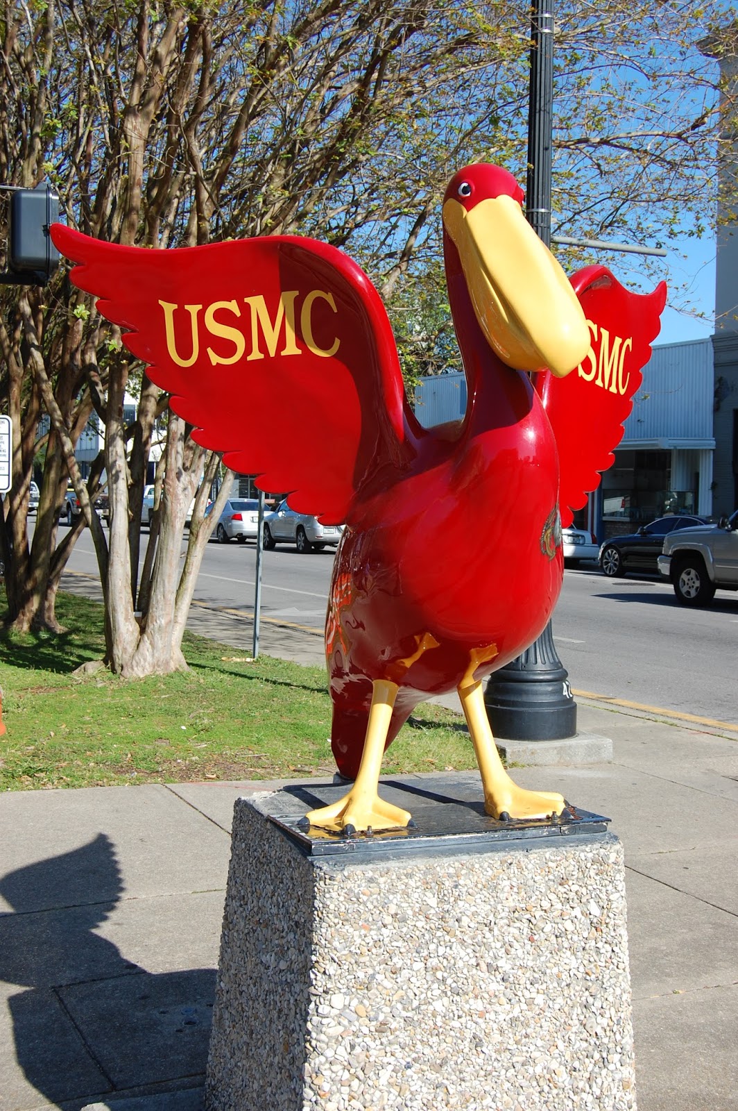
Twenty-one pelicans made up the original "flight" from 23 June - 3 July 2004.  The second flight of 15 launched November 15-19 and another flight of five were installed in 2005.  Many more have been added in the years since, totaling about 70 in all.  These fiberglass statues stand about five feet tall, weigh about 70 pounds and stand on bases that are about 450 pounds.  Most of these statues are concentrated into downtown Pensacola, although there are many in far-flung locations around the area.  Finding all of the pelicans has become a kind of scavenger hunt, and several people have created maps with photos of the various pelicans.  If you find a new one, you can add it to the maps along with your pictures.

Semper Fi - The Marine Pelican
N. Palafox and E. Garden
The first group that I saw were those honoring the US Armed Forces at the intersection of North Palafox and East Garden Streets.  It would take some doing to find and see all of the Pelicans on Parade.  Some have been vandalized, damaged or moved through the years.  Recently, the concrete base of many of these statues have been replace with pier pilings, giving them a much more nautical look.  If you visit downtown Pensacola - see how many you can catch!

Getting There 


Downtown Pensacola is most easily approached from the east (Tallahassee) or west (Mobile) from I-10.  The Downtown Pensacola exit (I-110 South) will take you into downtown onto Garden Street.

Waypoint: Latitude: 30.413097 N; Longitude: 87.215351 W

Street Address: N. Palafox Street and E. Garden Street

Further Reading


Do Pensacola Page
Visit Pensacola Page
Roadside Wonders Page


Marine Detail - Bac
Wild Blue - Air Force Pelican
N. Palafox and E. Garden
Wild Blue Back
Blue Angel-1: Navy Pelican
N. Palafox and E. Garden
Blue Angel 1 - Back
Salty - Coast Guard Pelican
N. Palafox and E. Garden
Salty Back

Army Pelican
N. Palafox and E. Garden

Wentworth Museum Pelican
S. Jefferson and E. Zarragossa
Florida Tourism Pelican
213 Palafox Place


Lighthouse Service Pelican
Pensacola Lighthouse

Monday, February 1, 2016

Bodacious Botanicals: Dotted Horsemint

Having studied biology on some level for more than 40 years, I have seen a wide variety of living organisms.  One of the most striking plants that I have seen is the Dotted Horsemint (Monarda punctata).  It grows to about three feet tall, with clusters of yellow tubular flowers with purple spots on the upper leaf axils.  The bracts (leaves near the flowers) turn white to lilac in color.  The stems are square, a hallmark of the mint family.  The leaves are spearhead shaped (lanceolate) to narrowly oblong and have hairs.  This plant grows in sandy soils from Vermont to southeastern Minnesota and down to Florida and Texas.  Interestingly, the dotted horsemint is missing from the Ohio River drainage.  Horsemint tends to grow in colonies, so if you find one plant, you will likely find others.

Also known as the spotted horsemint or spotted bee balm, the decorative flowers work well in butterfly gardens.  They bloom for a long time, and have showy foliage from July - October.  Pollinators include bumblebees, honeybees, plasterer bees, miner bees, wasps, swallowtail butterflies and the Karner blue butterfly.  Hummingbirds are attracted to the aromatic blossoms, as well.

Dotted horsemint has found many uses by humans through the years.  Being a member of the mint family, it produces several fragrant oils, and the Navajo used them to freshen the air in their hogans.  The plant has been used by several American Indian tribes as a medicine.  It has been used by tribes as diverse as the Meskwaki (Fox), Mohegan, Blackfoot and Nanticoke in teas and powders to relieve stomach cramps, cold, fever and flu.  Poultices on wounds can be used as an antiseptic. 


The plant produces a high content of thymol, which has known medicinal qualities.  Several mints are known to settle a queasy stomach when brewed into a tea.  Thymol can also be used to remove worms from the digestive tract, has antibacterial and antifungal properties.  Thymol has also been used as a miticide and fungicide in beehives.  It shows promise as a way of treating bacteria while reducing the incidence of antimicrobial resistance when used in tandem with antibiotics or antifungals.  Thymol also acts as a depressant through GABA-receptors, which explains some of the calming effects of herbal teas containing mints. 

This nice stand of horsemint was along the nature trail at Illiniwek Village State Historic Site in Clark County, Missouri.  This site contains the only known Illinois Indian village in Missouri.  Although the plant has a wide distribution, the first time I saw it was about 3 years ago on vacation with Nadienne. If you garden with native perennials east of the Rocky Mountains, this would be a showy addition to your collection.


Thursday, January 21, 2016

Home: William Frederick Cody

Buffalo Bill's Wild West Show Ticket Wagon
Some names are very memorable because of associations with things or events.  Yell "Marco!" in a crowd, and someone will probably holler back "Polo!".  If you use names in association games, "Jesse" will likely prompt "James", "Wyatt" will get you "Earp", and "Buffalo" will get you "Bill".  Buffalo Bill of the Wild West: Buffalo hunter, Pony Express Rider, Indian fighter, Army scout, Congressional Medal of Honor awardee, Wild West Show promoter.  Intrepid hero?  Consummate showman?  Ultimate fraud?  Who knows for sure, probably all of the above, just like most people.

Cody Homestead House - limestone portion is original
William Frederick Cody was born in a log cabin near LeClaire, Iowa Territory, just north of the modern-day Quad Cities on 26 February 1846.  His father Isaac Cody built a handsome house of limestone on a hill in the Wipsinicon River valley of Scott County, Iowa with walnut floors and trim.  The house stands today with some additions and serves as a museum to the Cody family and pioneer families of Iowa.  Although a celebrated native, William F. "Buffalo Bill" Cody did not spend much time at all here.  The family inhabited this particular house for scarcely a year.

Wooden frame additions to Cody Homestead
Isaac Cody, Bill's father, was a wandering sort.  From 1846-1853, the Cody's lived in four residences in and around LeClaire.  In 1850, Isaac set out for the California gold fields, but came home before he got very far, the reason for which was unknown to William Cody.  Kansas Territory was slated to open for settlement in 1854 and the family sold all of their Iowa properties in 1853 for $2000 (about $60,000 in 2016 dollars).  This may have been precipitated by the death of Samuel Cody, Bill's older brother, in a horse-riding accident.   In 1854, they left for Weston, Missouri, where Isaac's brother Elijah lived.

Bison kept on grounds of the Cody Homestead
Historic homes are interesting for several reasons, including: architectural style; sense of family style; sense of family status; and sense of family priorities.  A home can fill in some of the blank spaces in our picture of an individual.  Only two houses from Cody's boyhood are still in existence: this one and one that was moved from LeClaire to Cody, Wyoming.  Looking at this house, you can see the skill and care used by Isaac Cody to build the house, as it is still standing (with additions and renovations) after almost 170 years.  You also get the feeling that Isaac Cody liked the finer things in life, but was never quite satisfied with what he had, always chasing after the next better thing just beyond his reach.

The Codys in Kansas


Buffalo Bill's Wild West Show covered wagon
The move West was a fateful one for the Cody family.  Isaac's brother Elijah was a dry goods merchant and sold goods to emigrants on the Oregon-California Trail and settlers in Kansas at Weston, Missouri and Fort Leavenworth, Kansas Territory.  Elijah was also a slave-owner and supported the Border Ruffian cause to bring Kansas into the Union as a slave state.  Isaac originally expressed no strong political convictions, he was in Kansas for material gain.  The family settled in the Salt Creek Valley just north of Ft. Leavenworth (near present-day Kickapoo, KS), an area that was settled primarily by pro-slavery families.  Most people just assumed that Isaac was pro-slavery because they knew of his brother's stance.  When pushed to make a speech about his position at Rively's Store in Salt Creek Valley on 18 September 1854, Isaac tried to walk a fine line:  he was no abolitionist; where slavery was legal it should be left in place; he did not want to see slavery extended to new territories; in fact, he envisioned a white state in which no blacks, slave or free would be welcome.  The speech did nothing to help Isaac's position with either camp, and Charles Dunn, an employee of Elijah Cody's, stabbed Isaac twice in the chest with a Bowie knife, damaging a lung.

Wild West Show Poster
The attack was noted in the 28 September 1854 edition of the Democratic Platform (Liberty, Missouri):  "A Mr. Cody, a noisy abolitionist, living near Salt Creek, in Kansas Territory, was severely stabbed while in a dispute about a claim with a Mr. Dunn, on Monday week last. Cody is severely hurt, but not enough it is feared to cause his death. The settlers on Salt Creek regret that his wound is not more dangerous, and all sustain Mr. Dunn in the course he took. Abolitionists will yet find 'Jordan a hard road to travel!'”  You see that the notion of objective journalism is a fairly recent idea, and already out of style.

Although not active in Kansas politics up to that point, Isaac Cody became more outspoken as a Free Soil supporter and helped establish the Free State colony of Grasshopper Falls (now Valley Falls) on the Delaware River.  The Codys became marked, with pro-slavery men stealing their livestock and property, and threatening to kill Isaac should they find him.  Isaac began splitting time between Grasshopper Falls and the Salt Creek Valley, as the violence in "Bleeding Kansas" increased.  Despite the animosity between settlers in Kansas, the venom did not seem to spread in the Cody family, as Elijah continued to aid his brother and his family through the years.   In 1857, Isaac traveled to Ohio to recruit anti-slavery settlers to Grasshopper Falls.  Epidemics of scarlet fever and mumps broke out among the emigrants and Isaac Cody took ill.  He died of pneumonia at his home on 10 March 1857, his stab wounds listed as a contributing cause of death.  Isaac Cody was buried on Pilot Knob in Leavenworth, Kansas. This event pushed young William to look for work to support the family.  He found gainful employment with Russell, Majors and Waddell driving wagons at age 11.  William Cody was off on his life of adventure, becoming a personage as big as the American West itself.

Getting There


William F. Cody c. 1860
Exit I-80 at Exit 306 (LeClaire/Bettendorf) to US-67 north through LeClaire and Princeton, Iowa.  Turn west onto Bluff Road (CR-F33) just north of Princeton (you cannot miss the signs).  Take Bluff Road to 230th Ave.  Directly in front of you and just to the north will be the entrance to the Buffalo Bill Cody Homestead.  A small log schoolhouse is near the entrance, the house is further up the driveway.

Street Address: 28050 230th Avenue, Princeton, Iowa 52768

Waypoint: Latitude 41.713671 N; Longitude 90.4536868 W

Open every day April-October 9 AM - 5 PM
Admission $2

Just north on US-67 is a nice campground, Rock Creek Marina and Campground.  Turn east onto 291st Street to enter the campground.

The wagons pictured are actually in the Circus World Collection in Baraboo, Wisconsin on the grounds of what was the headquarters and winter quarters of the Ringling Brothers Circus.


Further Reading


An Autobiography of Buffalo Bill Cody

Buffalo Bill Cody Homestead

The Cody Graves in Leavenworth, KS

Monday, January 18, 2016

Pensacola Lighthouse

Pensacola Lighthouse from the beach
My Dad was in the Navy when I was growing up, and we moved all over the country in those first years, literally from sea to shining sea.  Some of my first memories are of the sounds of Newport, Rhode Island:  The sirens that sounded nothing like those on Dragnet (but sound like those in England); and the foghorn:  BAAAHHHHHHH-rummmmmmmm; silence;  BAAAHHHHHHH-rummmmmmmm.....  The foghorn works with a lighthouse to mark rocks/reefs/shoals and safe entrance to the harbor.

Lighthouses have always proved interesting to me.  At once utilitarian in function and aesthetic in design.  The sweeping beam that shows this navigational point to mariners for miles out to sea.  The earliest lighthouses were platforms upon which fires were built and lit at night.  The Argand lamp brought a smokeless light that could be placed in an enclosed tower, powered by whale oil.  Thorium lantern mantles provided a much brighter source of light.  Steam driven magnetos allowed electricity to be used to power carbon arc lamps.  The sun valve (which turned off gas flow during the day) and associated technology allowed the use of gas as a light source, until electric light technology became the standard.  Lights were rotated using multiple light sources and a clockwork system.  If the clockwork system failed, the works had to be turned by hand.

The first Pensacola Lighthouses


View next to Carriage House
The current Pensacola Lighthouse is the third example of a navigational light placed near this point.  The first Pensacola Light was a lightship, the Aurora Borealis, and was placed on the harbor side of Santa Rosa Island.  Although protected from the rough sea, it was often difficult to see from outside of the bay.

The second lighthouse was a 40 foot tower built on a 40 foot bluff at the mouth of the harbor, just west of Fort Barrancas and about a half mile east of the current lighthouse.  This building was entirely white and had 10 whale oil lamps in two clusters of five rotated by a clockwork and strengthened by a 14-inch reflector. An advantage of this light was that ships could follow the beam to enter the harbor, which was not possible with the placement of the light ship.  Despite the higher position, views of the  tower could still be blocked by trees close to the tower and those on Santa Rosa Island.  This first light would appear very stocky, 30 feet wide at the base, 15 feet wide at the top and 40 feet tall.

The third and current lighthouse

Lamp and lens - see the rainbow?
The current lighthouse was built in 1858 on the north side of the harbor entrance and entered service on 01 January 1859.  This tower is 150 feet tall on the side of a 40 foot bluff currently located on Naval Air Station Pensacola.  The light is 190 feet above sea level, which provides a considerable boost in visibility distance.  The lighthouse placement allows it to serve as the rear range light for the harbor entrance.  Range lights work in pairs, front and rear.  The rear light is always placed higher than the front light.  When the two lights form a vertical pair, the observer is on the navigation line.  If the front appears to the left of the rear, then the observer is right of the range line; if the front appears to the right of the rear, then the observer is left of range line.

Lens detail
The first lens for this light was a first order Fresnel lens.  These lenses had a large aperture and short focal length, this lens allows for more light to be collected from oblique sources.  These lights project a beam over a much broader distance.  The lens is divided into concentric annular sections.  A first order lens has a focal length of 920 mm and height of 2.59 meters.

When the US Civil War broke out in 1861, the harbor and the adjoining Navy Yard became a military target.  Union forces withdrew from Fort Barrancas and Fort McRee to Fort Pickens on Santa Rosa Island, leaving most of the harbor defenses and the Navy Yard in Confederate hands.  An artillery battle between Confederates in Ft. Barrancas and Ft. McRee on Perdido Key and the Union forces in Ft. Pickens on Santa Rosa Island broke out on 22 November 1861.  Shore batteries around the lighthouse became targets for Ft. Pickens.  During this time, the tower suffered about 6 hits.  Fortunately, none of the damage threatened the structural integrity of the tower. The Confederates evacuated Pensacola in May 1862. When Union forces came back to the tower, they found that the Confederates took the Fresnel lens with them.  On 20 December 1862, Union forces placed a fourth-order Fresnel lens in the tower, putting the tower back into service.

Entrance to Pensacola Bay
At the end of the war, the original Fresnel lens was recovered and put back into place in 1869.  The lightkeeper's residence was also built in 1869.  The daymark (paint scheme) of the tower was originally completely white, making it difficult to distinguish against a cloudy sky.  During the 1869 upgrades, the daymark was changed so that the lower third of the tower was left white to contrast it with nearby trees and the upper two-thirds of the tower was painted black to stand out against the sky. Electricity was installed in the light tower in 1939, which eliminated the need to rewind the clockwork by hand every 4 1/2 hours.

Fort Pickens on Santa Rosa Island
The light signature of this lighthouse is one white flash every 20 seconds.  The beam is very strong, being visible for 27 miles out to sea.  The lens continues to rotate during the day, even though the light is not powered.  This is necessary because the lens can focus a beam of light onto the wall of the lighthouse, creating a spot hot enough to damage the metal and masonry of the light room.  If the lighthouse loses electricity, the lens has to be moved by hand every few minutes to prevent this.

Stairs going down --- gives me the willies
The first lighthouse tower was constructed under the supervision of the Department of Treasury's Lighthouse Establishment (1791-1851).  The US Lighthouse Board of the Department of Treasury (1852-1910) was in charge during the construction of the second tower.  A more civilian Lighthouse Service within the Department of Commerce.  The Lighthouse Service was merged with the US Coast Guard in 1939 and light keepers were able to choose to remain civilians or join the Coast Guard.  The last civilian lightkeeper at Pensacola retired in 1953.  The Coast Guard operated the lighthouse from that point.  Automation reduced staffing needs in 1965.

End of Santa Rosa Island
The lighthouse was placed on the National Register of Historic Places in 1974.  By the 1980s, the site was in disrepair and a push to dismantle the outbuildings and perhaps the tower was increasing. The tower was seen as a potential hazard to jets flying out of NAS Pensacola.   Push-back from a preservation movement saved the Keeper's House and outbuildings from destruction.  In 1996, Coast Guard Auxiliary 17 started conducting tours of the lighthouse.  These were discontinued in 2007 due to liability concerns, and the grounds closed to the public.  The spiral staircase can be treacherous, with a railing only on the outside edge of the staircase.  The inside edge is unlined.  During the 177 stair climb, downstairs traffic has the right of way.  It is best for upstairs traffic to move toward the inside and hold onto a step at about eye-level, unless you can step into one of the deep window wells to let traffic pass.

In 2008, the Coast Guard allowed tours to resume under the supervision of the Pensacola Lighthouse Association.  Renovations continue on site.  The guide at the top of the tower was very well informed and helpful.  A small entry fee is charged to the site: $6.00 per adult when we went there.  The site is becoming increasingly popular, and there are a variety of tours with limited openings available at night, during Blue Angels practices and for Ghost tours.  Looking for a good place to propose?  This might be it.  Check the beach to see if someone has stomped out your message already, might save you some time and effort.

Getting There


The Pensacola Lighthouse is on the grounds of Naval Air Station Pensacola.  You will be required to present a valid picture ID for every adult in the vehicle and perhaps allow a search of the vehicle.  Have the IDs ready when you pull up to the gate.  The way is well marked, just follow the signs.  It is easy to see from the Museum of Naval Aviation.

Street Address: 2081 Radford Blvd, Pensacola, FL 32508

Waypoint: Latitude 30.3461433 degrees N ; Longitude 87.3104028 degrees W

Further Reading:

Pensacola Lighthouse and Museum


More views from the top


Lens detail

Fort McRee eroding into sea at end of Perdido Key


Above the airfield water tower

Carriage House - visitors center

Tip of Perdido Key


The kids at the top